Surface Features

Notable Landmarks
Mount Everest
Earth's tallest mountain above sea level, standing at 8,848 meters in the Himalayas.
Mariana Trench
The deepest oceanic trench, with the Challenger Deep reaching nearly 11,000 meters below sea level.
Himalayas
A massive mountain range formed by the collision of the Indian and Eurasian tectonic plates.
Grand Canyon
A massive canyon in Arizona carved over millions of years by the Colorado River.
Earth's Moon

The Moon
Earth's Moon is the fifth-largest natural satellite in the solar system. It stabilizes Earth's tilt, affects tides, and has been the only extraterrestrial body visited by humans.
Formation Theory
The leading theory suggests the Moon formed from debris after a Mars-sized body (Theia) collided with early Earth about 4.5 billion years ago.
Exploration
The Moon was first visited by humans during NASA's Apollo missions. More than 70 spacecraft have explored it, and new missions aim to establish a sustained human presence.
Earth Exploration History

TIROS-1
TIROS-1 was the first successful weather satellite, pioneering the use of space-based observation for meteorology by transmitting cloud cover images.

Landsat Program
A joint NASA-USGS program that has provided continuous Earth surface imaging since 1972, helping study agriculture, forestry, water, and climate.

GOES Satellite Program
NOAA’s GOES program has been continuously monitoring Earth’s weather and environmental systems from geostationary orbit for over 40 years. The program revolutionized real-time forecasting and severe weather alerts.

Copernicus Sentinel Missions
The Copernicus program, led by the European Space Agency, provides continuous Earth observation through Sentinel satellites for monitoring oceans, land, atmosphere, and climate change.

GRACE Mission
The GRACE mission tracked changes in Earth's gravity to study ice loss, groundwater depletion, and sea level rise.
Current Earth Missions
Sentinel-6
Sentinel-6 monitors global sea level rise with unparalleled precision to track climate change and ocean circulation.
Providing real-time ocean data used for climate modeling and weather forecasting.
Landsat 9
Landsat 9 continues the decades-long record of global land surface change, supporting research in agriculture, forestry, water use, and urban growth.
Delivering multispectral imagery every 8 days for climate and land management applications.
GOES-18
GOES-18 provides real-time monitoring of severe weather, wildfires, and solar activity over the Western Hemisphere.
Currently operational as GOES-West, replacing GOES-17 in the NOAA fleet.
Future Earth Exploration
Upcoming Missions
NISAR
A joint NASA-ISRO radar satellite designed to monitor natural hazards, ground deformation, and changes in ice, forests, and agriculture.
Earth System Observatory
NASA’s next-generation mission suite to observe the planet’s atmosphere, oceans, land, and climate systems with unprecedented precision.
Digital Twin Earth
ESA’s vision for a real-time simulation of Earth using AI, satellite data, and models to forecast climate and human impact scenarios.
Long-Term Visions

From climate forecasting to precision agriculture, the next frontier in Earth exploration lies in hyper-detailed simulations, AI integration, and global-scale environmental insight.
Challenges & Solutions
Planetary Defense
While rare, asteroid or comet impacts could cause catastrophic damage. Earth currently lacks a fully coordinated global defense system.
- Expand NEO detection programs (e.g., NEOWISE, Hera)
- Test kinetic impactors (like NASA’s DART mission)
- Establish global coordination for deflection missions
Climate Change
Rising temperatures, sea levels, and extreme weather events pose global risks.
- Satellite-based CO₂ tracking
- Policy-guided emissions modeling
- Global climate monitoring networks
Natural Disasters
Earthquakes, floods, and storms cause loss of life and infrastructure damage.
- Early warning satellite systems
- Real-time data for rapid response
- Remote sensing for recovery mapping
Earth Image Gallery

The Blue Marble
An iconic photograph capturing Earth in its entirety, showcasing the vastness and beauty of our planet.

International Space Station (ISS) Over Earth
A stunning view of the ISS orbiting above Earth's atmosphere, highlighting human presence in space.

Aurora Borealis from Space
A mesmerizing display of the Northern Lights as seen from orbit, illustrating Earth's magnetic interactions.

Earth and Moon Together
CA unique perspective showing both Earth and its Moon in a single frame, emphasizing our celestial neighborhood.

Global Biosphere Visualization
A satellite-derived image depicting Earth's vegetation and oceanic phytoplankton distributions.
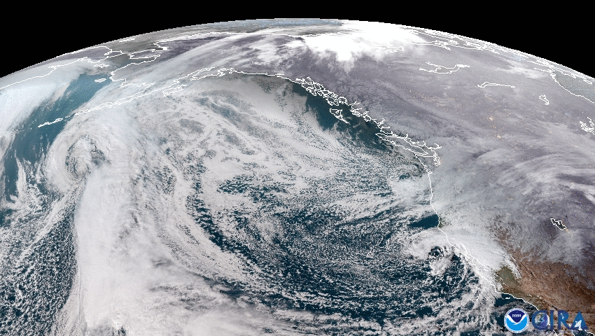
Weather Systems Captured by NOAA Satellite
A detailed image showcasing Earth's dynamic weather patterns and cloud formations.
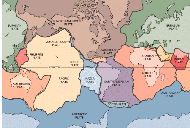
Tectonic Plates Map
An illustrative map outlining Earth's major tectonic plates and their boundaries.

Pale Blue Dot
A distant image of Earth taken by Voyager 1, portraying our planet as a tiny speck in the vastness of space.